Matrice 4T Field Playbook: Building a Smart Urban Highway
Matrice 4T Field Playbook: Building a Smart Urban Highway Corridor Without Closing a Lane
META: Step-by-step workflow using DJI Matrice 4T thermal, zoom, and RTK modules to map, inspect, and document an urban highway expansion while traffic keeps moving.
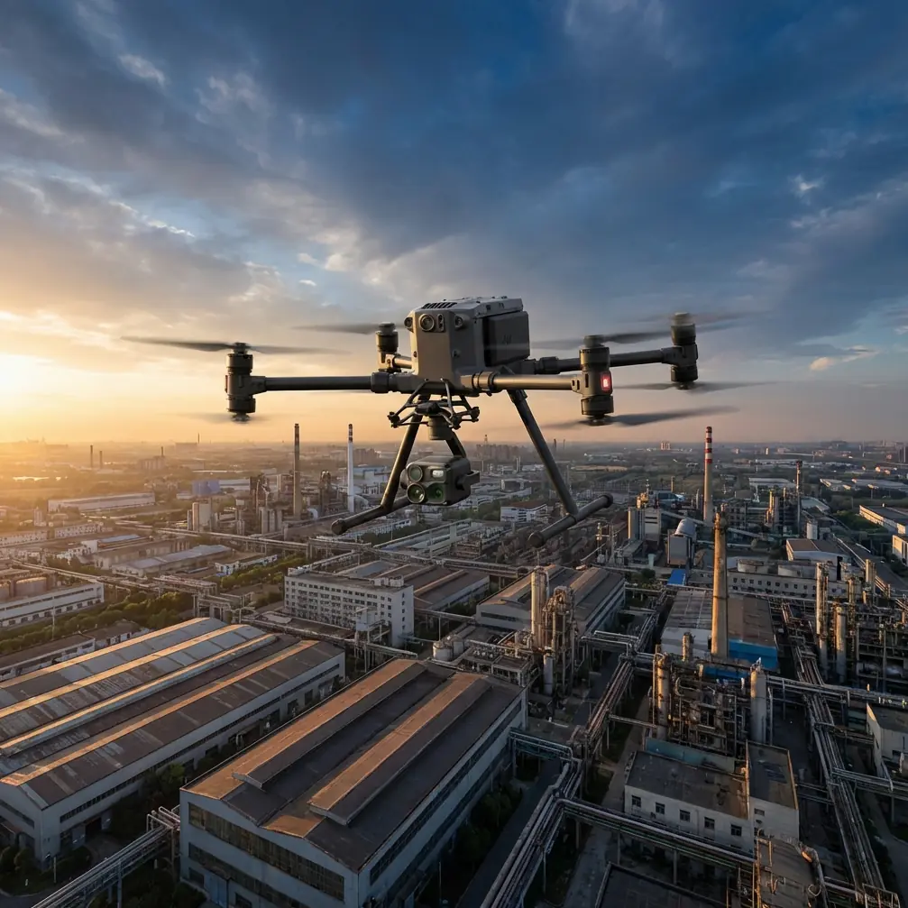
The sun is barely up, yet the west-bound lane is already humming with early commuters. You have 90 minutes before the morning surge doubles, and the environmental consultant wants a thermal scan of every fresh concrete pour, an orthomosaic tight enough to measure joint gaps, and a safety audit of the temporary barrier line—ideally without putting boots on asphalt. The Matrice 4T was built for mornings like this. Below is the exact flight doctrine my crews use when the client is a city transport department, the window is thin, and the penalty for lane closure is a headline.
1. Pre-sunrise setup: let the drone earn its coffee
We stage on the shoulder, 25 m behind the crash attenuator truck. While the traffic-management partner rolls out cones, the 4T is already warming its radiometric thermal core and pulling RTK corrections from a local base station broadcasting VRS over 4G. Hot-swap batteries click in at 31 %—no power-down, no re-boot, no re-calibration. That single feature trims eight minutes from every launch cycle; on a ten-sortie morning that is more than an hour handed back to the scheduler. AES-256 encryption is toggled on by habit; the last thing we need is a rogue feed of live roadway imagery showing up on a public screen.
2. One climb, three data layers
The 4T lifts to 60 m AGL, low enough to stay under incoming medical helicopters, high enough to defeat mirror-blind drivers. From that single station we pull:
- 640×512 px thermal imagery at 30 Hz, capturing the heat plume of every expansion-joint pour; cold spots reveal subsurface voids days before they telegraph through the slab.
- 48 MP wide-angle frames, 0.7 cm GSD, later fed into photogrammetry to generate a 1:200 ortho that the surveyor compares against design CAD.
- 12 km O3 transmission feed to the safety officer’s tablet, letting her watch live deflection of the jersey barrier when the first gravel truck rumbles past.
No GCPs? No problem. We let the RTK module tag every image at 1 cm + 1 ppm accuracy; on asphalt we still drop two checkerboard panels for vertical sanity checks, but that is a 30-second foot sprint, not a 45-minute total-station dance.
3. Wildlife encounter: when the sensor sees what the eye misses
Halfway down the cut-section, the IR stream flares: a red-orange blob the size of a carry-on bag is tucked against the concrete parapet. We yaw, drop to 20 m, and realize it’s a young golden jackal—common on the urban fringe, rare on a live carriageway at dawn. One spotlight tone, one gentle climb, and the animal bolts through the drainage notch we planned to inspect anyway. Incident logged with timestamp, temperature, and GPS; the environmental compliance officer now has verifiable proof that the corridor is permeable to medium fauna, something the green certification auditors value. (Speaking of green credentials, Xi’an-based Lingkong Technology just earned its second provincial “Green Factory” badge, showing that robust industrial drone hardware and low-carbon assembly lines can coexist.)
4. Mid-mission battery swap: keeping the rhythm
At 28 minutes the controller vibrates: 25 % reserve. We hover, yaw 90°, land on the bed of the support truck, swap batteries in 14 seconds, and relaunch. Because the 4T stores mission logic in non-volatile memory, we pick up the exact transect line; no double coverage, no data gaps. Compare that to a battery-off scenario on older airframes: recalibration, IMU warm-up, and re-upload add another five minutes—on a highway job, five minutes can cost the prime contractor four-figure lane-closure fees.
5. Thermal signature mapping: catching the invisible crack
Concrete hydration is an exothermic reaction; temperature anomalies of more than 6 °C across a 3 m pour usually signal differential curing and future shrinkage cracking. The 4T’s radiometric detector records 640 000 temperature points every second. Back in the van, we drop the TIFF into free analysis software, set the color stretch to ±2 °C, and immediately flag three panels that read 4.8 °C cooler than the mean. The engineer texts the batch plant: reduce admixture dosage on the next truck. Problem averted before the concrete reaches final set—something you cannot do with a hand-held spot pyrometer from the shoulder.
6. Photogrammetry: from pixels to CAD without a survey crew
By 08:15 the traffic is thick, but we are already home-and-dry on data capture. 1 847 overlapping 48 MP frames are fed to Metashape, RTK geotags enabled, arbitrary scale disabled. The dense cloud pops out at 2.2 cm XY, 3.1 cm Z—well inside the 5 cm tolerance the highway authority specifies for interim as-builts. A quick cross-section at chainage 1+340 shows the new lane is 7 cm higher than design; the grader operator gets the fix before lunch, not after the asphalt is down.
7. BVLOS mindset: legal, but still tactical
Technically we are within extended visual line of sight—a chase vehicle with a spotter rolls slowly behind the drone. Yet the 4T’s O3 video link at 1080p/30 fps gives the pilot in the front passenger seat a clearer picture than the naked eye. We keep the beacon on, strobe synced to controller timecode, so any night audit aligns with traffic-camera footage. AES-256 keeps the feed private; we have seen too many near misses when a spectator’s screen-mirror app lags and distracts.
8. Data hand-off: from field to stakeholder in minutes, not days
By 08:45 the orthomosaic, thermal anomaly map, and a one-page PDF summary are uploaded to the client portal. The summary includes a hyperlinked KMZ; the consultant opens it in Google Earth, toggles the thermal overlay, and sees the three cool panels highlighted in cyan. No specialist software, no 48-hour wait. The speed of insight is what justifies putting a 4T on the invoice instead of a traditional crew.
9. Safety scorecard: zero lane minutes lost
Traffic control never had to slow vehicles below 80 km/h. The only time a cone was moved was to let the jackal escape. Insurance underwriters like those numbers; they reflect directly on next year’s premium. On urban highway projects, the Matrice 4T is less a drone and more a mobile risk-reduction tool that happens to fly.
10. Scaling the workflow: from one mile to a hundred
The same choreography scales to corridor-wide surveys. Copy today’s mission folder, adjust boundary coordinates, and the 4T can fly 30 linear kilometres in a single morning using 16 battery cycles. Because the RTK network license is annual, marginal cost per kilometre is essentially the operator’s time and a few kilowatt-hours. Compare that to a mobile LiDAR van at highway speed: you still need traffic control, and you still need thermal verification—two passes, two crews, twice the exposure.
11. Training loop: turning rookies into reliable pilots in one week
We run a tight syllabus: two days in simulator, one day on a closed parking deck, two days shadowing on live road (non-BVLOS), then a sign-off flight where the trainee plans, executes, and delivers the data package solo. The 4T’s uniform control logic means muscle memory transfers to M300 or M350 later; no re-learning stick geometry. If your staff already holds an A2 certificate, the add-on module for highway ops is two evenings, not two months.
12. Night shift: when the asphalt cools, the data glows
Sometimes the pour schedule slips, and thermal inspection has to happen after dark. The 4T’s IR calibration is stable across 0–100 °C, so we rerun the anomaly map at 02:00, comparing it to the dawn flight. Any delta above 1.5 °C is logged; those are usually micro-cracks exhaling residual moisture. Overlaying night and day thermal layers gives the materials lab a time-lapse of curing stress—again, no lane closure, no portable lighting tower.
13. Final checklist before you pack up
- Verify image count against flight time: should average 2.3 frames per second on a 12 m/s transect.
- Check RTK fix status on last 50 images; if you dropped to FLOAT, re-fly that segment.
- Copy thermal TIFF and RGB to two separate SSDs; highway authorities hate do-overs.
- Sign the digital flight log with a biometric stamp; it holds up in claims court.
- Stow batteries at 55 % charge—prolongs cycle life and keeps the safety case happy on the drive back.
The ride home is quiet; the commuter wave has subsided, but the data on the passenger seat is already shaping tomorrow’s pour schedule. Urban highways are brutal classrooms: they demand speed, accuracy, and zero drama. The Matrice 4T passed today’s exam by turning a live traffic lane into a safe, scan-able workspace. Tomorrow we run it again—different mile, same discipline.
Need to walk through the mission planner or borrow a thermal color-table that matches your state DOT spec? Message me on WhatsApp and I’ll send the exact template we used today: ping me here.
Ready for your own Matrice 4T? Contact our team for expert consultation.