Matrice 4T in Mountain Construction: A Field Report on What
Matrice 4T in Mountain Construction: A Field Report on What Actually Matters
META: Expert field report on using the Matrice 4T for mountain construction site filming, thermal observation, route planning, battery strategy, and fast image processing for safer, more useful aerial outputs.
Mountain construction projects expose every weak point in a drone workflow. Thin launch areas. Broken terrain. Wind that changes direction by the minute. Long linear assets such as access roads, retaining walls, pipe routes, and utility corridors that are easy to miss from the ground and slow to document on foot.
That is where the Matrice 4T becomes interesting—not because it is a spec-sheet trophy, but because it fits a very specific kind of job: getting reliable visual and thermal intelligence from difficult sites without slowing the project team down.
I have seen crews approach mountain documentation as if the drone is the whole solution. It is not. The aircraft is only one part of the chain. The real result depends on three linked decisions:
- choosing the right aircraft behavior for the terrain,
- designing a route that respects mountain conditions,
- turning captured data into something the site team can use the same day.
The reference material behind this piece comes from an older but still relevant pipeline inspection workflow and a rapid mosaic-processing solution. On paper, those sources are not about the Matrice 4T directly. In practice, they describe the operational logic that still separates useful drone work from wasted flights.
Why mountain construction sites resemble pipeline jobs more than film sets
One of the source documents focuses on UAV use in long-distance oil and gas pipeline operations. That may sound unrelated to construction filming, but the overlap is obvious in the field. Both jobs involve stretched-out corridors, elevation changes, safety constraints, and the need for fast feedback.
The source lays out a simple truth: different UAV types solve different problems. Fixed-wing platforms cover large areas efficiently and can stay aloft for 2 to 4 hours, but they need more room for launch and recovery, and they cannot hover. Multirotors are the opposite. Their endurance is shorter—typically 20 to 30 minutes in the source material—but they can hover, reposition precisely, and work in tighter spaces.
That distinction matters enormously in mountain construction.
A fixed-wing aircraft may be ideal for broad corridor reconnaissance, but when you are filming a cut slope, crane pad, bridge pier, or staged excavation on a narrow ridge, hover is not a luxury. It is the job. The Matrice 4T belongs in that second category of work: close, deliberate, repeatable observation where framing accuracy and access flexibility matter more than maximum endurance.
The same source also notes that many UAVs in industrial use operate within a working temperature range of -20°C to 50°C, with wind tolerance often topping out around Force 5. Those numbers are not there for decoration. In mountain work, they become planning constraints. Morning air can be cold enough to affect battery behavior; afternoon gusts can be strong enough to make a previously clean orbit around a structure unstable or unsafe. A pilot who ignores those realities usually blames the aircraft for what was actually a mission-planning mistake.
The real advantage of the Matrice 4T on steep sites
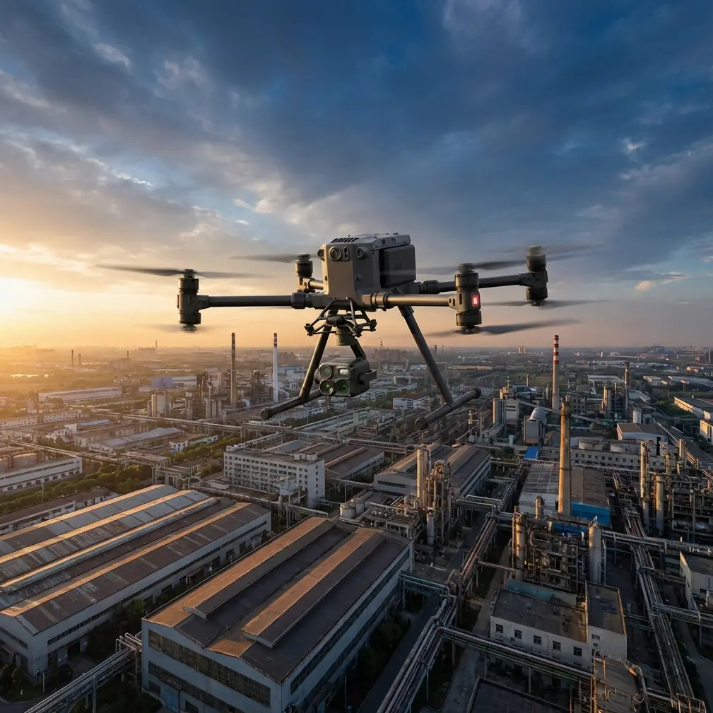
For construction readers, the Matrice 4T’s value is not just image capture. It is the combination of stable visual documentation, thermal signature detection, and repeatable position control in places where access from the ground is slow or risky.
On mountain sites, that means three practical uses rise to the top.
1. Progress capture that shows more than pretty angles
A superintendent does not need cinematic footage alone. They need proof. Has the bench cut advanced? Is drainage installed where the drawing says it should be? Has a haul road edge started to deform after rain? Are stockpiles migrating into restricted areas?
A multirotor platform is strong here because it can stop, hold, and revisit exactly the same perspective at regular intervals. That creates meaningful comparison over time. If the route is designed well and altitude is kept consistent, weekly flights become visual records, not just promotional clips.
2. Thermal context where visual imagery can mislead
Thermal is often underused on construction sites because teams think of it only for search tasks or specialist inspection. On mountain jobs, thermal can help reveal uneven moisture retention, drainage behavior near retaining systems, and heat differences across recently placed materials or equipment zones. It is not a replacement for engineering analysis, but it can point the team toward anomalies worth checking.
The operational significance is simple: visual cameras tell you what the slope looks like; thermal can hint at where conditions are behaving differently than expected.
3. Safer observation of difficult access zones
The source document on industrial UAV workflows emphasizes pre-flight reconnaissance, collection of GPS waypoints and elevation data, and route design based on terrain maps. That advice remains current. In mountain construction, some of the most useful flight footage comes from places you should not send a surveyor on foot just to “have a look.” Fresh cuts, narrow ledges, unstable spoil edges, and partially built access tracks are exactly where aerial observation saves time and reduces exposure.
Route design is where mountain flights are won or lost
One line from the pipeline workflow stands out: flight planning should review terrain carefully and preload the route into the control system, while allowing immediate switching between programmed control and manual remote control during flight.
That is not theory. It is exactly how I approach mountain site missions with the Matrice 4T.
A preplanned route gives consistency. It helps with repeatable photogrammetry, regular progress records, and efficient battery use. But mountain sites are too dynamic to trust automation blindly. Wind spillover off ridgelines, moving machinery, dust plumes, cable hazards, and temporary structures all demand the ability to intervene instantly.
This is where modern transmission reliability and secure links matter. Strong O3-class transmission behavior helps the pilot maintain confidence when terrain starts blocking line quality, and AES-256 level data protection matters when project imagery includes sensitive infrastructure layouts or commercially sensitive construction sequencing. For major contractors and utility-linked jobs, secure handling of flight data is no longer optional.
Still, transmission quality does not cancel out physics. If the site has severe terrain masking, the right answer may be to reposition the pilot station, split the mission into shorter legs, or use visual observers. People who talk casually about BVLOS in mountain environments often skip the hard part: topography can turn a theoretically simple route into a signal-management problem within seconds. Operationally, conservative route segmentation usually beats trying to stretch a single flight too far.
A battery management tip I learned the hard way
Here is the field habit I insist on with multirotor operations in the mountains: do not treat battery percentage as your true reserve. Treat terrain, climb requirement, and wind exposure as part of the reserve.
On a flat site, crews often get comfortable landing when the pack reaches a familiar threshold. In mountain work, that can be a bad habit. If you descend into a valley side to capture a retaining wall or lower road cut, the return may require a sustained climb into headwind. The battery that looked comfortable at the low point can feel much smaller on the way home.
My rule is simple. If the outbound leg includes descent below the launch elevation, I ask a different question before continuing: “Do I have enough power to come back uphill in worse wind than I have right now?” If the answer is unclear, I stop the shot and recover.
Hot-swap batteries help keep the day moving, but they do not excuse poor energy judgment. In cold morning conditions, I also prefer a short stabilization hover after takeoff before committing to a long leg, just to confirm the power system is behaving normally. It costs a little time. It saves more than that.
Fast processing is not a luxury when the site team is waiting
The second reference source, despite its messy extract, points to something many drone operators still undervalue: rapid mosaic processing through software such as Pixel-Mosaic.
This matters because construction managers rarely need “drone data” in the abstract. They need a stitched, interpretable output they can act on. A clean mosaic, generated quickly after landing, can show haul route encroachment, bench progression, drainage line continuity, material spread, or equipment staging patterns while the team is still on site.
The first source explicitly mentions that UAVs equipped with high-resolution aerial cameras can perform mapping-grade photography, then produce fast or refined mosaics after landing to provide timely ground and spatial data. That sentence could have been written for today’s mountain construction workflow. Capture alone is not the deliverable. Actionable geospatial context is.
If you are flying the Matrice 4T for site documentation, that means thinking beyond video clips. Build a mission stack that supports both visual communication and photogrammetry. If the project needs measurement confidence, integrate GCPs where practical and safe. On sites where GCP placement is difficult because of slope access or active earthworks, be transparent about the accuracy class of the output. A fast orthomosaic without proper control can still be highly useful for progress interpretation, but everyone should understand what it is—and what it is not.
The right mountain workflow looks boring on paper
The strongest Matrice 4T operations are usually not flashy. They are disciplined.
A typical productive sequence looks like this:
- site reconnaissance to verify launch and recovery area,
- review of visibility, lighting, and wind behavior,
- route planning tied to terrain and project priorities,
- focused capture passes for both visual and thermal needs,
- battery swaps before power margins become debatable,
- immediate post-flight review,
- quick mosaic or stitched output for the field team,
- refined processing later if the project needs higher-grade mapping products.
That mirrors the pipeline source’s workflow logic almost exactly: determine flight range, gather waypoint and altitude information, evaluate weather, design the route carefully, then execute with procedural checks. The aircraft may be newer; the discipline has not changed.
What construction teams should expect from a good Matrice 4T operator
They should expect someone who understands that mountain filming is not just filming.
A capable operator should know when to prioritize oblique imagery over straight-down capture, when thermal adds value and when it is just extra data, when a corridor pass should be broken into multiple missions, and when weather conditions are still technically flyable but operationally unhelpful.
They should also be able to explain the significance of aircraft limitations in plain language. For example:
- A multirotor’s shorter endurance, compared with fixed-wing systems that may remain airborne for 2 to 4 hours, is not necessarily a weakness on tight mountain sites. It is the tradeoff that buys hover precision and flexible launch access.
- A wind environment that approaches Force 5 may still be within broad capability ranges mentioned in industrial UAV references, but mountain gust patterns can create local instability well before a published threshold becomes the deciding factor.
That is the kind of translation that helps project teams trust the workflow.
Final thoughts from the field
The Matrice 4T is at its best on mountain construction sites when it is treated as a decision-support tool, not a flying camera alone. Its value comes from precision hovering, thermal context, controlled route repetition, and the ability to convert difficult terrain into clear visual records quickly.
The two reference threads behind this article—industrial pipeline UAV operations and rapid mosaic generation—lead to the same conclusion from different directions. Good aerial work is not defined by launch. It is defined by what happens before takeoff and after landing.
If you are planning a mountain construction documentation workflow and want to compare mission design, thermal use, or processing strategy, you can message our field team directly here.
Ready for your own Matrice 4T? Contact our team for expert consultation.