Matrice 4T for Urban Power-Line Filming: What Actually
Matrice 4T for Urban Power-Line Filming: What Actually Matters in the Field
META: A technical review of the Matrice 4T for urban power-line filming, with practical insight on thermal signature work, transmission reliability, safety around wildlife, and why disaster-response lessons still shape real-world drone operations.
When people search for a drone to film power lines in a city, they often start with sensor specs and stop there. That misses the real question. Urban utility work is not won by a brochure. It is won in messy airspace, around reflective rooftops, live infrastructure, moving traffic, and the sort of unpredictable details that force crews to adapt on site.
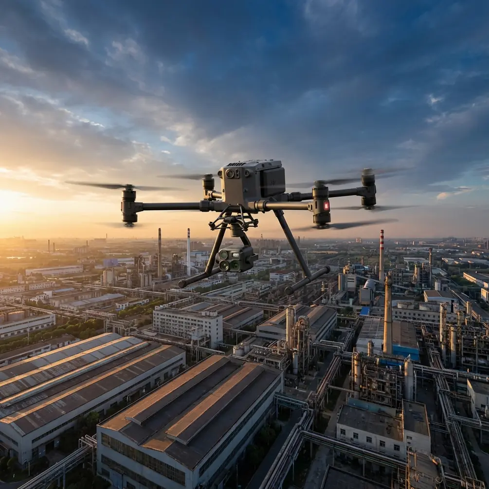
That is where the Matrice 4T deserves a more serious look.
I am framing this review around a specific operational reality: filming power lines in urban environments where the mission may blend visual documentation, thermal checks, roofline context, and rapid decision-making. The most useful reference point here is not a lab test. It is the documented role drones played in southeast Texas during the Houston disaster response, when operators from across the U.S. helped first responders identify downed power lines, damaged roofs, and even locate pets in affected neighborhoods. That single field report captures three things urban utility crews still deal with today: electrical hazards, structural context, and human unpredictability.
The Matrice 4T fits that kind of work because it is not just a camera carrier. It is a situational-awareness platform.
Why the Houston response still matters to a Matrice 4T buyer
The 2017 Houston deployment is worth revisiting because it was not a cinematic exercise. Drone teams were used for practical aerial intelligence. Spotting downed power lines is very different from making clean inspection footage of intact overhead distribution in a normal city block, but the operational logic overlaps almost perfectly.
First, utility imagery is never only about the line.
A useful sortie often needs to show conductor position, nearby rooftops, tree encroachment, pole hardware, access constraints, and signs of secondary damage. In Houston, drones were used to identify damaged roofs alongside electrical hazards. That combination matters because roof damage, debris fields, and unstable structures can alter safe launch positions and flight paths in dense neighborhoods. A platform like the Matrice 4T becomes more valuable when its thermal signature workflow and visual payload can help crews read the whole scene rather than isolate a single asset.
Second, the fact that drone teams also helped locate pets is not a throwaway human-interest detail. It points to something urban operators know well: low-altitude work near homes often includes unexpected living obstacles. On one recent utility corridor job, a crew had to reroute around a red-tailed hawk perched on a crossarm and later reduce altitude transition speed near a rooftop where a pair of feral cats kept darting across a narrow service alley. This is precisely where a multi-sensor aircraft has an advantage. You are not just avoiding collision; you are preserving mission continuity without escalating risk. Thermal can help distinguish living heat sources tucked into visual clutter, especially around shaded roof voids, vegetation edges, or debris piles.
In other words, the Houston report was an early public demonstration of what many enterprise pilots now take for granted: drones become truly valuable when they reduce ambiguity fast.
The Matrice 4T is strongest when the mission is layered
For urban power-line filming, the Matrice 4T makes the most sense when the job is not purely cinematic and not purely thermographic. Its strength is the ability to gather multiple forms of evidence in one deployment.
That matters because urban utility clients increasingly want more than a simple video pass. They may need:
- a visual record for engineering review
- thermal imagery for anomaly screening
- contextual imagery of adjacent roofs or façades
- mapping outputs tied to photogrammetry and GCP workflows
- secure handling of sensitive infrastructure media
The Matrice 4T sits in that overlap well.
A thermal payload is the obvious draw, but thermal alone can mislead if detached from geometry and surface context. A heat irregularity near a line attachment point may reflect load, emissivity differences, sunlight retention, or environmental masking. When a drone can collect thermal and conventional imagery in tight coordination, interpretation improves. For urban power-line filming, that means fewer blind spots in the handoff between field crew and analyst.
This is also where O3 transmission matters more than many operators admit. In a city, signal integrity is not just about distance. It is about surviving interference, line-of-sight interruptions, and the cluttered RF environment around concrete, glass, and active communications infrastructure. Stable transmission affects framing, safety, and the operator’s ability to make small decisions in real time. When you are holding a precise angle on conductors running past mixed-height buildings, hesitation in the video link is not a minor annoyance. It can compromise the whole pass.
Urban power lines are a structural problem, not just a flight problem
One of the more interesting pieces in the reference material is not about drones at all. The aircraft structural design text discusses optimization as an iterative process: start from an initial design, analyze it, choose a direction that improves the objective, then take a step and repeat. It also notes a classic limitation of early mathematical planning methods: as design variables increase, iteration counts rise sharply.
That engineering logic applies surprisingly well to drone inspection planning in cities.
Urban power-line filming has too many variables for a rigid one-pass mentality. Wind channeling between buildings, rooftop reflections affecting thermal readings, moving vehicles near takeoff, restricted launch footprints, and changing utility priorities all add variables. The best Matrice 4T operations are run like iterative optimization, not like prewritten choreography.
A competent crew will begin with an initial route, evaluate line-of-sight and heat conditions, adjust altitude or orbit shape, then tighten the path on later passes. That is essentially the same pattern described in the structural optimization text: analyze, choose a better direction, step forward. The operational significance is practical. With a multi-sensor platform, you do not need to solve every variable before takeoff. You need a system that supports disciplined refinement in the field.
There is a second lesson in that structural reference. It contrasts strict mathematical methods with more mechanics-based approaches that may be less elegant but can reach near-optimal outcomes without iteration exploding as complexity rises. For Matrice 4T users, that translates into pilot judgment. In dense utility corridors, the best result often comes from combining software planning with field-tested heuristics: maintaining conservative standoff around energized assets, adjusting thermal collection timing to avoid false heat patterns from sun-soaked façades, and using contextual roof imagery to support maintenance interpretation.
Not every mission benefits from theoretical perfection. Many benefit from resilient decision-making.
Thermal work in cities needs discipline
Thermal signature capture sounds straightforward until you try it over mixed urban surfaces. Asphalt, membrane roofs, metal flashings, HVAC exhaust, mirrored windows, and shaded vegetation all complicate the image. The Matrice 4T is useful here because the operator can cross-reference suspected anomalies instead of treating every hot or cold patch as actionable.
For power-line filming, the practical workflow should usually move in stages.
Start broad. Establish corridor context and identify where line geometry intersects buildings, trees, and service entrances. Then narrow in on components or spans that justify closer review. Finally, capture confirming visual angles so downstream reviewers are not forced to interpret thermal data in isolation.
This approach echoes the Houston disaster-response model in miniature. Crews did not use drones only to find one object type. They used them to sort a chaotic environment into actionable categories: power hazards, roof damage, living subjects. The Matrice 4T is at its best when deployed with that same mindset.
Mapping support is often underrated in utility filming
A lot of buyers treat “filming” and “mapping” as separate procurement buckets. In the field, they frequently overlap.
If an urban utility client needs corridor context, access planning, or a documented change record after maintenance, photogrammetry can add real value. Where accuracy matters, GCP integration remains relevant even with a capable enterprise aircraft. You may not run full survey-grade workflows on every power-line mission, but when rooftop offsets, pole surroundings, or asset adjacency need defensible spatial context, mapping discipline helps.
The Matrice 4T is not only a line-inspection tool; it is a bridge between imaging and documentation. That distinction matters for teams trying to reduce repeat visits. Every avoided return flight saves time, battery cycles, road closures, and coordination overhead.
Security and continuity are not side issues
Utility footage is sensitive. Even when the work is routine, imagery may reveal infrastructure layouts, access points, and maintenance conditions. That is why data handling should be part of the purchase conversation. AES-256 matters here not as a checklist item but as an operational control for organizations that cannot treat media security casually.
Battery strategy matters just as much. Hot-swap batteries sound mundane until you are halfway through a structured corridor capture window with traffic management in place and only a narrow period of favorable lighting. Continuity between sorties preserves consistency in thermal and visual capture, especially when the crew needs to repeat flight lines for comparison. On urban infrastructure jobs, friction comes from interruptions. Features that reduce those interruptions improve output quality more than marketing copy suggests.
BVLOS talk should be kept realistic
BVLOS is one of those terms that gets inserted into every enterprise drone conversation whether it fits or not. For urban power-line filming, the real issue is not whether the Matrice 4T can be associated with BVLOS workflows in theory. It is whether your operation, regulatory framework, urban terrain, and risk controls support it responsibly.
In most city utility scenarios, even when extended corridor work is desired, the immediate value usually comes from robust visual-line-of-sight execution with disciplined positioning, reliable transmission, and clean sensor coordination. Pushing for range without solving data quality, interference management, and safety around structures is the wrong priority.
A real-world note on wildlife and situational awareness
The brief reference to pets in the Houston operation deserves one more mention because it captures something many inspection plans omit: the environment is inhabited.
On one urban line-filming assignment near a substation perimeter, the crew picked up an unusual thermal patch moving along a parapet edge during a roof-adjacent pass. It turned out to be a small dog that had somehow accessed a service roof from a neighboring structure. The mission paused, not because the animal created a direct flight hazard, but because its movement would have contaminated the thermal interpretation around a cable route. That is not dramatic. It is normal field reality. A drone like the Matrice 4T earns its keep when it helps the crew separate electrical, structural, and biological signals without confusion.
If you want to compare deployment setups or mission-fit details with someone who understands this type of workflow, this direct WhatsApp line is practical: https://wa.me/85255379740.
So who is the Matrice 4T really for?
Not every urban operator needs it. If your work is limited to simple daylight documentation of accessible poles, there are lighter and cheaper ways to get footage. The Matrice 4T becomes compelling when the mission combines inspection pressure, mixed-sensor demands, and the need to interpret more than one layer of the environment at once.
That includes teams filming:
- power lines running close to occupied buildings
- roof-adjacent utility assets
- storm-affected urban corridors
- heat-related anomalies requiring visual confirmation
- infrastructure packages where security and repeatability matter
The key point is this: the Matrice 4T should be judged less by headline features and more by how it handles ambiguity. The best evidence for that standard is hidden in the Houston response story. Drones were useful because they helped crews identify downed power lines, assess roof damage, and locate pets in the same operating environment. That is a blueprint for modern urban drone work. Real missions are mixed. The aircraft that can sort the mix efficiently is the one that keeps delivering value.
For urban power-line filming, the Matrice 4T stands out when the operator needs one platform to provide clean visual context, meaningful thermal insight, secure data handling, and enough link reliability to work around city interference without constant compromise. Add disciplined mission planning, sensible GCP-backed documentation where needed, and battery continuity through hot-swap operations, and you have a drone that is genuinely suited to the job rather than merely marketed toward it.
Ready for your own Matrice 4T? Contact our team for expert consultation.