Matrice 4T in High-Altitude Vineyards: A Specialist Case
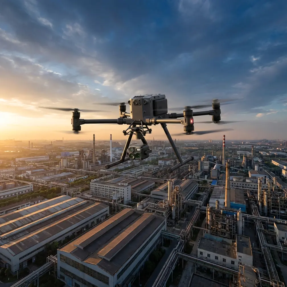
Matrice 4T in High-Altitude Vineyards: A Specialist Case Study on Flight Height, Signal Integrity, and Safer Data Capture
META: A field-based Matrice 4T case study for filming high-altitude vineyards, with practical guidance on flight altitude, thermal signature quality, transmission reliability, and mission safety.
I’ve spent enough time around mountain vineyards to know that the hardest part is rarely getting a drone into the air. The hard part is getting usable footage and repeatable data when terrain, wind, cold batteries, glare, and uneven canopy geometry all start working against you at the same time.
For operators using the Matrice 4T in high-altitude vineyard environments, the usual “fly higher for coverage, lower for detail” advice is too shallow to be useful. The better question is this: at what altitude does the aircraft still deliver stable visual, thermal, and mapping results without compromising transmission quality or forcing too many battery swaps on a steep site?
That is the question this case study is built around.
The scenario: high-altitude vines are visually beautiful, operationally unforgiving
Let’s define the mission clearly. The objective is filming vineyards located at elevation, where rows often run along uneven slopes, terraced blocks, and narrow access corridors. In these settings, the Matrice 4T isn’t just a camera platform. It becomes a sensing and documentation tool. One pass may be intended for cinematic visuals, the next for thermal signature review, and another for photogrammetry support tied to GCP-based reconstruction.
This combination changes how you choose altitude.
At lower elevations on flat farmland, pilots can often hold a simple rule of thumb. In mountain vineyards, that shortcut breaks down because relative height above the crop changes constantly as the aircraft moves across slope transitions. A nominal 60-meter mission can become effectively much lower over a ridgeline and much higher over a drop-off two rows later. That affects image scale, overlap consistency, thermal readability, and the stability of obstacle awareness.
The Matrice 4T is well suited to this kind of mixed mission profile, but only if altitude planning is treated as a data-quality variable, not merely an airspace variable.
My field recommendation: start around 45 to 70 meters above canopy, then adjust by mission type
If I were advising a team filming high-altitude vineyards with the Matrice 4T, I would usually begin test passes in the 45 to 70 meter above-canopy range, not above takeoff point. That distinction matters.
Why this range?
Because vineyard work at altitude has two competing needs:
- You need enough standoff to smooth terrain-induced flight corrections and preserve safer line geometry over rows.
- You need to stay low enough to preserve canopy structure detail, row separation, and meaningful thermal contrast.
For pure cinematic passes, you may occasionally climb above that band for establishing views. For operational imaging, especially if you want actionable thermal or mapping output, that band is often the sweet spot. In many real vineyards, 60 meters above canopy is a very efficient starting point because it balances coverage with detail while reducing the dramatic angle shifts that happen when flying too low across terraced sections.
The mistake I see most often is pilots setting altitude from launch point and assuming consistency. On a mountain vineyard, that can produce wildly uneven capture geometry. If the aircraft is 60 meters above takeoff but only 30 meters above an upper terrace, your footage and sensor output can change abruptly. The better method is terrain-aware planning with altitude judged relative to the vine canopy itself.
Why signal quality matters more in vineyards than many pilots expect
People tend to think of drone signal reliability as a distance problem. In vineyards, especially high-altitude ones, it’s often a geometry problem.
Slopes, retaining walls, row orientation, tree lines, stone buildings, and ridge shoulders can all interfere with clean transmission paths. This is where the Matrice 4T’s O3 transmission capability becomes practically significant. A strong link isn’t just about keeping video on screen. It helps the pilot maintain confidence during oblique passes, turns along contour lines, and repositioning between blocks where the aircraft briefly drops against a complex terrain background.
There’s an engineering principle in the reference material that helps explain why this matters. One source defines maximum noise level as the greatest electrical noise a circuit can tolerate before performance degrades. Another explains distortion as impurity introduced by nonlinearity in a signal path. Those are avionics terms, but the operational lesson translates cleanly to drone work: once your link environment becomes noisy or unstable, performance loss is not always dramatic at first. It often shows up as small degradations—hesitation in monitoring, less trustworthy video interpretation, or reduced confidence in edge-of-block maneuvers.
In vineyard filming, those small degradations matter. A pilot aligning with tight row geometry or checking subtle canopy stress in a thermal view cannot afford to normalize unstable signal behavior.
So when I recommend 45 to 70 meters above canopy, part of the reasoning is transmission hygiene. That altitude band often improves line-of-sight consistency compared with lower passes that tuck the drone too deeply into terrain contours. In other words, flight height is not just a visual decision. It can be a link-quality decision.
Thermal work in vineyards: altitude directly changes what “hot” actually means
The Matrice 4T’s thermal capability is one reason it’s compelling for vineyard teams. But thermal signature interpretation in vineyards is highly sensitive to altitude, solar loading, wind exposure, and canopy density.
At high altitude, you often get cleaner morning air and stronger contrast windows, but also more abrupt microclimate variation across slopes. A south-facing block and a shaded terrace can present very different thermal behavior within the same mission.
If you fly too high, thermal anomalies blur into generalized patterns. If you fly too low, your coverage efficiency drops and the angle of view may exaggerate localized canopy temperature differences that are not representative across the row. Again, this is why I like beginning around 60 meters above canopy for broad assessment, then descending for verification over suspect areas.
There’s another useful concept from the reference data: dynamic range, described there as the ratio between maximum and minimum signal power measured in dB. In practical imaging terms, vineyard operators can think of dynamic range as the room a sensing system has to separate subtle differences instead of collapsing them together. That mindset is useful when planning thermal flights. Your goal isn’t merely to “see heat.” It’s to preserve enough separation between cooler and warmer vine zones that the thermal layer means something after the flight.
Altitude affects that separation. So does timing. Thermal flights in vineyards should be treated as measurement exercises, not as generic aerial shooting.
Mapping and photogrammetry: don’t let beautiful footage undermine survey discipline
Many vineyard clients ask for one mission that does everything: marketing footage, thermal review, top-down maps, and sometimes a 3D model for drainage or planting analysis. The Matrice 4T can support parts of this mixed workflow well, but only if the operator separates creative capture from survey capture.
For photogrammetry, especially in steep vineyards, consistent overlap and reliable ground control are what protect output quality. This is where GCP placement still matters. High-altitude sites often tempt teams to skip careful control because access is difficult. That shortcut usually shows up later as misalignment along terraces, edge warping, or poor reconstruction in areas with repetitive row texture.
If the objective includes measurable outputs, I advise clients to establish visible GCPs across elevation changes, not only at easy access points. The drone can collect the imagery, but the terrain will punish lazy control strategy.
The reference material also includes a concept called generation, essentially a revision counter used to manage interface changes in a database. That may sound far removed from drone operations, but it is exactly the kind of discipline serious vineyard programs need. If you’re building repeatable inspections, every mission profile should be versioned: altitude band, overlap settings, time-of-day window, thermal palette, GCP layout, and even route direction relative to row orientation. When a result improves, that mission should become the new generation. When a parameter changes, document it. Otherwise, seasonal comparison becomes guesswork disguised as analytics.
That is one of the less glamorous reasons professionals get better results from the same aircraft. They don’t just fly missions. They manage mission revisions.
Battery strategy on mountain blocks: hot-swap changes how you plan the day
High-altitude vineyards consume time in small ways. Transit between blocks takes longer. Wind can be more turbulent near saddles and ridgelines. Climb segments cost energy. And operators lose efficiency whenever they need to power down completely between short capture windows.
This is where hot-swap batteries become operationally meaningful. Not because the feature sounds advanced, but because it reduces friction in fragmented fieldwork. On a vineyard with multiple separated parcels, the ability to keep moving between thermal spot checks, facade shots of terraces, and mapping legs can preserve the best lighting and temperature windows.
I encourage crews to plan battery use by block, not by total day. That sounds obvious, but many teams still plan from a gross flight-time estimate. In vineyards, one exposed upper parcel with stronger wind may demand very different reserve thinking than a sheltered lower block.
Cold conditions at elevation also make battery discipline less forgiving. A smooth battery rotation plan helps maintain consistency across repeated runs, especially if you are trying to compare thermal signatures or lighting conditions between adjacent sections.
Safety logic from larger aviation systems applies surprisingly well here
One of the most interesting reference details comes from a discussion of aircraft monitoring circuits. The source describes a system with two channels: one used for control, the other acting as a reference path for fault detection. If the comparison exceeds a threshold, the system shifts into a safer state.
That philosophy is worth borrowing for Matrice 4T vineyard operations.
In civilian drone work, your “two channels” can be procedural rather than hydraulic or analog. For example:
- Primary channel: live pilot judgment during the mission
- Reference channel: preplanned route, terrain profile, and sensor objectives checked before takeoff
Or:
- Primary channel: visual camera mission
- Reference channel: thermal or mapping confirmation pass
When the two disagree, pause and resolve the discrepancy.
If the live view says coverage is fine but your overlap map suggests gaps on the uphill terraces, trust the reference and refly. If the thermal image suggests stress but the visible canopy pass shows deep shadow contamination, do a validation orbit instead of over-interpreting the first result.
The reference source also describes a window threshold that triggers a fault response when deviation becomes too large. This is a powerful mental model for drone crews. Build your own threshold windows before launch. Examples:
- Wind gust spread beyond your acceptable stability range
- Link quality drops below your comfort level in a given block
- Canopy-relative altitude variance exceeds what your mapping objective can tolerate
- Thermal contrast becomes unreliable due to sun angle or late-day heating
Once any of those parameters moves outside the window, stop treating the mission as routine. Reconfigure or postpone.
That is how professionals avoid bad datasets and unnecessary risk.
Transmission security and client confidence
For many commercial vineyard operators, especially those managing premium estates, media handling is not a trivial issue. The Matrice 4T’s AES-256 support matters less as a marketing bullet and more as part of a credible data-governance posture. Vineyard flights can capture infrastructure, access roads, worker movement, fermentation buildings, irrigation layouts, and experimental blocks. Some clients care deeply about where that information goes and how it is protected in transit.
This becomes even more relevant when missions are coordinated across consultants, agronomists, and remote stakeholders, or when a team is preparing procedures that may later support BVLOS workflows under appropriate civil regulatory frameworks. Secure transmission and disciplined record-keeping are not extras. They are part of building a program mature enough to scale.
If you’re evaluating a vineyard workflow and want to compare route logic or payload setup with someone who has done this in steep terrain, I’d suggest using this direct field planning chat rather than improvising around your first mountain parcel.
What altitude should you actually choose on your next vineyard mission?
Here’s the practical answer I give most often.
If you are filming high-altitude vineyards with the Matrice 4T, begin with a mission plan built around roughly 60 meters above canopy. Then adapt:
- 45 to 55 meters above canopy for stronger vine detail, tighter thermal review, and selected oblique storytelling passes
- 60 to 70 meters above canopy for balanced operational coverage, more stable geometry over uneven slopes, and cleaner route consistency
- Higher only when the objective is broad contextual footage, not detailed analytical capture
Then validate the plan against four questions:
- Does the altitude remain consistent relative to canopy, not just takeoff point?
- Does your O3 link remain stable across terraces and ridge transitions?
- Is the thermal signature still distinct enough to support interpretation?
- Are your photogrammetry settings and GCP placement aligned with the terrain, not just convenience?
That combination is what turns a Matrice 4T flight from attractive footage into reliable vineyard intelligence.
The aircraft is capable. The deciding factor is usually whether the operator respects the mountain environment enough to plan for signal integrity, fault thresholds, and repeatable data capture. The references behind this discussion may come from traditional aerospace design concepts—noise tolerance, distortion, configuration generation, monitored fault transitions—but the lesson is immediate for drone work: good missions come from controlled systems, not from guesswork.
Ready for your own Matrice 4T? Contact our team for expert consultation.