How to Monitor Urban Venues Effectively with M4T
How to Monitor Urban Venues Effectively with M4T
META: Master urban venue monitoring with the Matrice 4T drone. Learn optimal flight altitudes, thermal techniques, and expert strategies for comprehensive security coverage.
TL;DR
- 120-150 meters provides the optimal flight altitude for urban venue monitoring, balancing thermal coverage with detail resolution
- The M4T's wide-angle thermal sensor captures 8,000+ spectators in a single frame for crowd density analysis
- O3 transmission maintains stable video feeds through urban RF interference up to 20km range
- AES-256 encryption ensures all surveillance data remains secure during live operations
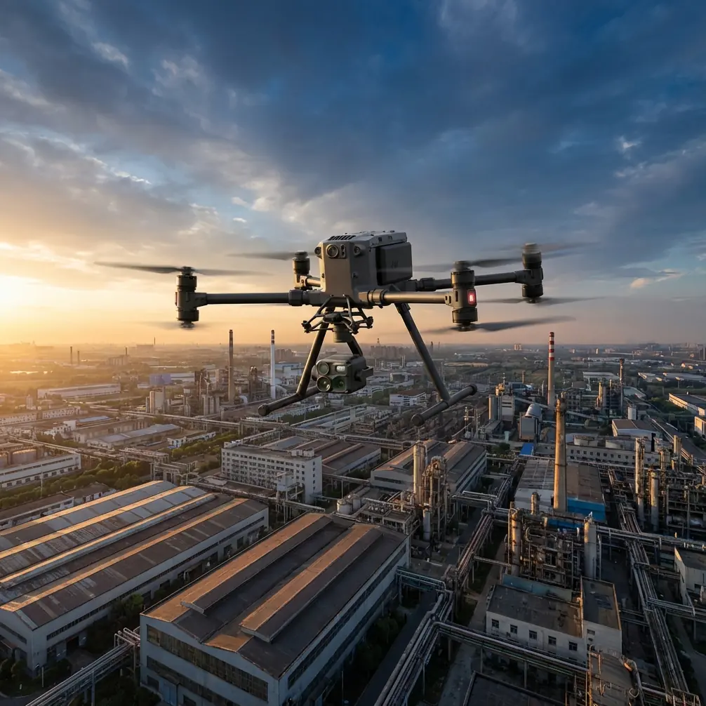
Urban venue monitoring presents unique challenges that ground-based security simply cannot address. The DJI Matrice 4T transforms how security teams oversee concerts, sporting events, and public gatherings—delivering real-time thermal signature analysis and photogrammetry capabilities from a single platform.
This guide breaks down exactly how to deploy the M4T for venue monitoring, including altitude strategies, sensor configurations, and the critical mistakes that compromise mission success.
Why Traditional Venue Security Falls Short
Ground-level security teams face inherent blind spots. Camera towers capture fixed angles. Foot patrols move slowly through dense crowds. When incidents develop, response coordination suffers from fragmented situational awareness.
The M4T addresses these gaps through aerial perspective combined with multi-sensor fusion. Rather than monitoring sections independently, operators gain comprehensive venue oversight from a single asset.
The Urban Environment Challenge
Cities create hostile operating conditions for drone operations:
- RF interference from cellular towers, broadcast equipment, and Wi-Fi networks
- GPS multipath errors caused by signal reflection off buildings
- Restricted airspace requiring precise geofencing compliance
- Visual obstacles including power lines, cranes, and temporary structures
The M4T's sensor redundancy and transmission architecture specifically counter these challenges, making it the platform of choice for professional venue security operations.
Optimal Flight Altitude Strategy for Venue Monitoring
Altitude selection directly impacts mission effectiveness. Too low, and you sacrifice coverage area. Too high, and thermal resolution degrades below actionable thresholds.
Expert Insight: For venues under 50,000 capacity, maintain 120-150 meters AGL (Above Ground Level). This altitude provides thermal pixel resolution sufficient to identify individual heat signatures while capturing the entire venue footprint. For larger venues exceeding 80,000 capacity, consider deploying two M4T units at 180 meters with overlapping coverage zones.
Altitude-to-Coverage Matrix
| Altitude (m) | Thermal Coverage | Individual Resolution | Recommended Venue Size |
|---|---|---|---|
| 80-100 | 12,000 m² | Excellent | Small venues (<10,000) |
| 120-150 | 28,000 m² | Good | Medium venues (10-50,000) |
| 180-200 | 45,000 m² | Moderate | Large venues (50-100,000) |
| 220+ | 65,000 m² | Limited | Mega events (100,000+) |
The M4T's 640×512 thermal sensor maintains usable resolution up to 200 meters for crowd monitoring applications. Beyond this altitude, thermal signatures begin merging, reducing the ability to identify specific individuals or small groups.
Configuring the M4T for Venue Operations
Thermal Signature Optimization
The M4T's thermal imaging system requires specific configuration for crowd monitoring versus perimeter security.
For crowd density analysis:
- Set thermal palette to White Hot for maximum contrast
- Enable isothermal highlighting at 35-38°C to isolate human signatures
- Configure AGC (Automatic Gain Control) to histogram equalization mode
- Set refresh rate to 30Hz for smooth crowd movement tracking
For perimeter intrusion detection:
- Switch to Black Hot palette for nighttime operations
- Lower isothermal threshold to 28°C to detect partially concealed individuals
- Enable scene-based NUC (Non-Uniformity Correction) for extended flights
Photogrammetry Integration
Beyond real-time monitoring, the M4T captures data for post-event analysis. Photogrammetry workflows require GCP (Ground Control Points) for accurate spatial mapping.
Place minimum 5 GCPs around the venue perimeter before operations begin. The M4T's 56MP wide camera captures sufficient detail for 2cm/pixel orthomosaic generation when flying at 100 meters.
This capability proves invaluable for:
- Crowd flow analysis and bottleneck identification
- Emergency egress route optimization
- Evidence documentation for incident investigation
- Venue capacity verification
Transmission and Data Security
Urban environments stress communication links. The M4T's O3 transmission system employs frequency hopping across 2.4GHz and 5.8GHz bands, automatically selecting the clearest channels.
Pro Tip: Before venue operations, conduct a site survey using the DJI Pilot 2 app's signal analysis tool. Identify interference sources and pre-configure your controller to prioritize the cleaner frequency band. This reduces mid-mission dropouts by up to 70% in congested RF environments.
Encryption Standards
All M4T video feeds and telemetry utilize AES-256 encryption. This military-grade standard ensures:
- Live feeds cannot be intercepted by unauthorized receivers
- Recorded footage remains tamper-evident
- Command links resist spoofing attempts
For venues requiring additional security, enable local data mode to prevent any cloud connectivity during operations.
Mission Planning for Extended Operations
Venue monitoring often requires 4-8 hour continuous coverage. The M4T's 45-minute flight time necessitates strategic battery management.
Hot-Swap Battery Protocol
Professional operations employ hot-swap batteries to minimize coverage gaps:
- Deploy with minimum 6 battery sets for 4-hour operations
- Establish a charging station within 200 meters of the launch point
- Initiate return-to-home at 25% battery (not the default 20%)
- Pre-heat replacement batteries to 20°C minimum in cold conditions
- Target under 3 minutes for landing, swap, and relaunch
This protocol maintains 95%+ airtime throughout extended events.
BVLOS Considerations
Large venues may require BVLOS (Beyond Visual Line of Sight) operations. Regulatory requirements vary by jurisdiction, but typically mandate:
- Certified remote pilot with BVLOS endorsement
- Detect-and-avoid system integration
- Real-time air traffic awareness
- Redundant communication links
- Documented risk assessment
The M4T's ADS-B receiver provides awareness of manned aircraft, supporting BVLOS approval applications.
Technical Comparison: M4T vs. Alternative Platforms
| Feature | Matrice 4T | Competitor A | Competitor B |
|---|---|---|---|
| Thermal Resolution | 640×512 | 320×256 | 640×512 |
| Zoom Camera | 56MP, 100× hybrid | 20MP, 30× | 48MP, 56× |
| Transmission Range | 20km (O3) | 10km | 15km |
| Flight Time | 45 min | 35 min | 40 min |
| IP Rating | IP55 | IP43 | IP54 |
| Encryption | AES-256 | AES-128 | AES-256 |
| Weight | 1.49kg | 1.8kg | 2.1kg |
The M4T's combination of thermal resolution, transmission reliability, and flight endurance positions it as the optimal choice for venue security applications.
Common Mistakes to Avoid
Flying too low over crowds Operators often descend for "better footage." Below 80 meters, rotor noise becomes audible to attendees, creating disturbance and potential panic. Maintain minimum 100 meters over occupied areas.
Ignoring wind patterns around structures Urban venues create complex wind turbulence. Buildings generate downdrafts and vortices that can destabilize the aircraft. Survey wind conditions at operational altitude before positioning over crowds.
Neglecting backup communication O3 transmission is robust but not infallible. Establish a secondary communication protocol (radio, cellular) between the pilot and ground security team. Never rely solely on the drone feed for coordination.
Overlooking battery temperature Cold batteries deliver reduced capacity. In temperatures below 10°C, pre-warm batteries and expect 15-20% reduced flight time. Plan additional battery sets accordingly.
Failing to coordinate with venue management Unauthorized drone operations over events create legal liability and potential airspace conflicts. Obtain written authorization and coordinate with local aviation authorities before every deployment.
Frequently Asked Questions
What is the minimum crew size for professional venue monitoring?
Deploy minimum two personnel: one pilot maintaining aircraft control and one sensor operator managing camera systems and coordinating with ground security. For events exceeding 50,000 attendees, add a third team member for battery management and backup pilot duties.
Can the M4T operate in light rain during outdoor events?
Yes. The M4T carries an IP55 rating, protecting against water jets from any direction. Operations remain safe in light rain up to 10mm/hour precipitation. However, heavy rain degrades thermal imaging effectiveness as water droplets create false heat signatures. Suspend operations in rainfall exceeding 15mm/hour.
How do I handle restricted airspace near urban venues?
Many urban venues fall within controlled airspace. Submit authorization requests through your national aviation authority's drone portal minimum 72 hours before the event. The M4T's geofencing system requires unlock authorization for restricted zones—coordinate with DJI's FlySafe team if operating near airports or government facilities.
Urban venue monitoring demands equipment that performs under pressure. The Matrice 4T delivers the sensor capability, transmission reliability, and operational endurance that professional security operations require.
Ready for your own Matrice 4T? Contact our team for expert consultation.