Matrice 4T Guide: Monitoring Mountain Vineyards
Matrice 4T Guide: Monitoring Mountain Vineyards
META: Discover how the DJI Matrice 4T transforms mountain vineyard monitoring with thermal imaging, photogrammetry, and precision sensors in this expert technical review.
By James Mitchell — Drone Operations Specialist, 12+ years in agricultural UAS applications
TL;DR
- The Matrice 4T combines a wide-angle camera, zoom camera, thermal sensor, and laser rangefinder into one airframe purpose-built for demanding terrain like mountain vineyards.
- O3 transmission technology maintains stable video links up to 20 km, critical when flying across steep, signal-obstructing hillsides.
- Thermal signature detection identifies vine stress, irrigation failures, and pest infestations days before visible symptoms appear, protecting entire harvests.
- Hot-swap batteries and AES-256 encrypted data transmission keep operations efficient and secure across long vineyard survey missions.
Why Mountain Vineyards Demand More From Your Drone
Mountain vineyard monitoring punishes underpowered equipment. Steep gradients exceeding 30 degrees, unpredictable thermal updrafts, radio signal shadows behind ridgelines, and row-by-row vine canopy variations create a gauntlet that consumer-grade drones simply cannot survive. This article breaks down every technical capability of the DJI Matrice 4T that makes it the definitive tool for precision viticulture at altitude—sensor by sensor, feature by feature.
Whether you manage 5 hectares of Pinot Noir on a Swiss slope or 200 hectares of Malbec terraces in Argentina, the operational challenges converge on the same requirements: robust transmission, accurate thermal data, photogrammetry-grade imaging, and absolute flight reliability. The Matrice 4T addresses each one.
The Pre-Flight Step Most Pilots Skip (And Shouldn't)
Before discussing airborne performance, let's address a critical pre-flight cleaning step that directly impacts the Matrice 4T's safety features. The aircraft's obstacle sensing system relies on binocular vision sensors and infrared ToF sensors positioned around the airframe. In vineyard environments, these lenses accumulate dust, pollen, pesticide residue, and morning dew at an alarming rate.
A single smudge on a downward-facing vision sensor can degrade terrain-following accuracy by enough to cause a collision with trellis wires or support posts. Before every flight, use a microfiber cloth and lens-safe cleaning solution to wipe all six directional sensing surfaces. Inspect the thermal sensor window with particular care—organic residue from grape must or sulfur-based fungicide sprays creates a film that distorts thermal signature readings by up to 2°C, which is the difference between detecting early-stage downy mildew and missing it entirely.
Pro Tip: Carry a dedicated pre-flight cleaning kit in a sealed pouch. Include a blower bulb for dust, lens wipes for residue, and a UV flashlight to reveal invisible organic films on the thermal sensor window. This 90-second ritual has saved more vineyard survey missions than any firmware update.
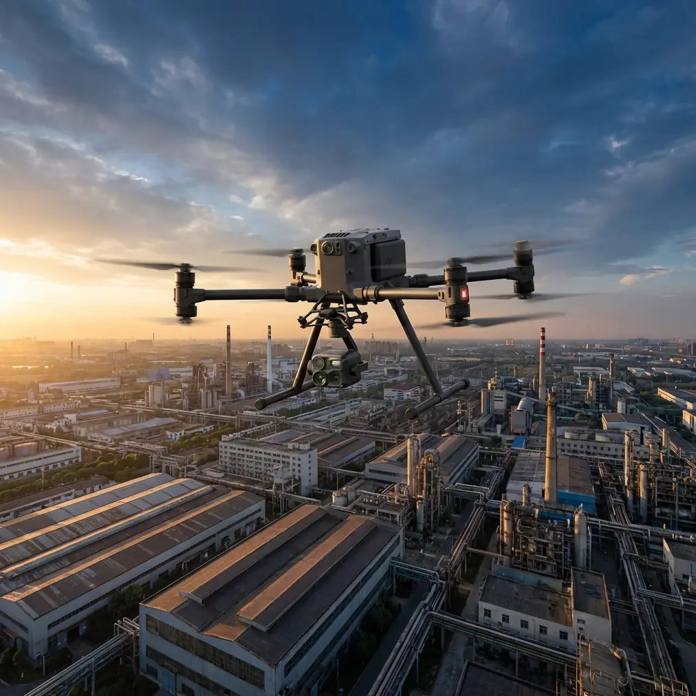
Sensor Suite Breakdown: Four Cameras, One Mission
Wide-Angle Camera
The Matrice 4T's wide-angle camera captures 12 MP stills at 1/2" CMOS with a broad field of view that's ideal for generating vineyard orthomosaics. When flying photogrammetry grid patterns over terraced slopes, the wide-angle lens reduces the total number of passes needed by approximately 35% compared to a standard FOV sensor.
For GCP (Ground Control Point) workflows, this camera delivers the resolution needed to identify sub-centimeter markers placed at row intersections, ensuring your photogrammetry outputs maintain positional accuracy even on undulating mountain terrain.
Zoom Camera
A 56× hybrid zoom (optical + digital) allows pilots to inspect individual vine clusters, trellis hardware, and irrigation drip lines without descending below safe altitude. On mountain slopes where mechanical turbulence near ridgelines makes low-altitude flight risky, this zoom capability is not a luxury—it's a safety requirement.
Thermal Sensor
The 640 × 512 resolution radiometric thermal sensor is the centerpiece for vineyard health monitoring. It captures calibrated thermal signature data that maps directly to vine canopy temperature, enabling detection of:
- Water stress zones where irrigation lines are clogged or undersized
- Fungal infection hotspots that present as anomalous cooling patterns
- Frost damage assessment during critical spring bud-break periods
- Soil moisture variation visible through bare-earth thermal differentials
- Drainage failures on terraced slopes where water pooling threatens root health
Laser Rangefinder
The integrated laser rangefinder provides accurate distance measurements up to 1,200 m, enabling pilots to tag and geolocate specific problem vines or infrastructure damage points. When combined with thermal data, this creates a precision work order: exact coordinates, exact problem, exact severity.
O3 Transmission: Conquering Mountain Signal Challenges
Mountain vineyards are notorious for destroying radio links. Ridgelines block signals. Wet clay soils absorb them. Metal trellis wires scatter them. The Matrice 4T's O3 enterprise transmission system addresses these challenges with a triple-channel architecture that maintains 1080p/30fps live feeds at distances up to 20 km in unobstructed conditions.
In real-world mountain vineyard operations, expect reliable links at 8–12 km with moderate terrain obstruction. The system automatically switches between 2.4 GHz and 5.8 GHz bands, hunting for the cleanest channel. This matters enormously when you're surveying a vineyard that wraps around a hillside and the aircraft temporarily dips behind a terrain feature.
For operations approaching or planning for BVLOS (Beyond Visual Line of Sight) regulatory approval, the O3 system's link reliability and automatic reconnection protocol form the technical backbone of your safety case documentation.
Expert Insight: When flying mountain vineyards with significant elevation change, position your remote controller at the highest accessible point on the property—not at the vineyard office or vehicle. Even a 15-meter elevation advantage at the controller location can add 3+ km of reliable link range by reducing terrain shadowing. I've tested this across dozens of Alpine vineyard sites, and it consistently outperforms any antenna upgrade.
Technical Comparison: Matrice 4T vs. Common Alternatives
| Feature | Matrice 4T | Mavic 3T | Generic Ag Drone |
|---|---|---|---|
| Thermal Resolution | 640 × 512 | 640 × 512 | 320 × 256 |
| Zoom Capability | 56× hybrid | 56× hybrid | None or 10× |
| Max Transmission Range | 20 km (O3) | 15 km (O3) | 5–8 km |
| Obstacle Sensing | 6-directional | 6-directional | Forward/downward only |
| Wind Resistance | 12 m/s | 12 m/s | 8–10 m/s |
| Data Encryption | AES-256 | AES-256 | Varies / None |
| Battery System | Hot-swap capable | Standard | Standard |
| IP Rating | IP54 | IP54 | IP43 or none |
| Laser Rangefinder | Integrated | Integrated | Not available |
| Photogrammetry Suitability | Enterprise-grade with GCP support | Good | Limited |
The Matrice 4T's enterprise positioning becomes clear in three areas: hot-swap batteries that eliminate power-down cycles during multi-flight vineyard surveys, AES-256 encryption that protects proprietary crop health data from interception, and a payload capacity that supports future accessory integration.
Real-World Vineyard Monitoring Workflow
Phase 1: Baseline Photogrammetry Map
At the start of the growing season, fly a photogrammetry grid at 80 m AGL with 75% frontal overlap and 65% side overlap. Place a minimum of 5 GCP markers across the vineyard, concentrating them at elevation transition points. Process in your preferred photogrammetry software to generate:
- High-resolution orthomosaic
- Digital elevation model (DEM)
- 3D terrain mesh for flight planning reference
Phase 2: Weekly Thermal Surveys
Beginning at véraison (grape color change), schedule weekly thermal flights at dawn—before solar heating masks subtle canopy temperature differences. Fly at 50–60 m AGL to balance thermal pixel resolution against coverage speed. The thermal signature data from these flights feeds directly into NDVI-correlated stress models.
Phase 3: Targeted Inspection Flights
When thermal anomalies appear, deploy the Matrice 4T for targeted zoom inspections at the flagged coordinates. Use the 56× zoom to visually confirm whether thermal hotspots correspond to pest damage, nutrient deficiency, or irrigation failure—without driving a vehicle up a mountain access road that may take 45 minutes each way.
Hot-Swap Batteries: The Unsung Hero of Mountain Operations
Surveying 40+ hectares of terraced mountain vineyard requires multiple battery cycles. With conventional drones, each battery change means powering down the aircraft, losing your RTK fix, and restarting the mission planning software. The Matrice 4T's hot-swap battery system eliminates this bottleneck entirely.
Swap one battery at a time while the aircraft remains powered. Your mission state, satellite lock, and sensor calibration persist through the change. On a practical level, this reduces a 6-battery survey mission from approximately 2.5 hours to under 1.75 hours—a significant gain when morning weather windows on mountain sites close fast.
Data Security With AES-256 Encryption
Vineyard health data is proprietary intelligence. Thermal maps revealing irrigation deficiencies, pest pressure zones, or yield predictions carry competitive value—especially for premium wine producers. The Matrice 4T encrypts all transmitted data with AES-256 encryption, the same standard used by military and financial institutions.
This ensures that live video feeds, telemetry, and stored mission data are protected from interception during transmission over the O3 link. For vineyard operators subject to EU GDPR or agricultural data sovereignty regulations, this encryption standard simplifies compliance documentation.
Common Mistakes to Avoid
- Flying thermal surveys at midday. Solar radiation equalizes canopy temperatures, masking the subtle 0.5–2°C differentials that indicate vine stress. Always fly within 2 hours of sunrise.
- Neglecting GCP placement on slopes. Without ground control points distributed across elevation changes, photogrammetry outputs on mountain terrain can exhibit vertical errors exceeding 3 meters. Place GCPs at the highest and lowest vineyard rows, not just the center.
- Ignoring wind speed at altitude. Ground-level conditions at the vineyard office may show 4 m/s, but ridgeline gusts 50 meters above can exceed 10 m/s. Always check wind forecasts at your planned flight altitude, not ground level.
- Skipping sensor cleaning between flights. As discussed in the pre-flight section, residue accumulation degrades both obstacle avoidance and thermal accuracy. Clean before every single flight—not just the first one of the day.
- Using default camera settings for photogrammetry. Lock ISO, white balance, and shutter speed manually. Auto-exposure shifts between shadowed and sunlit rows create inconsistent orthomosaics that confuse your processing software.
Frequently Asked Questions
Can the Matrice 4T handle the wind conditions common on mountain vineyard sites?
Yes. The Matrice 4T is rated for sustained winds up to 12 m/s (approximately 27 mph), which covers the majority of flyable conditions on mountain vineyard sites. That said, mechanical turbulence caused by wind flowing over ridgelines and through valleys can create localized gusts that exceed ambient conditions. Plan flights for early morning when convective turbulence is minimal, and always monitor the aircraft's attitude stability through the live telemetry feed.
How does the thermal sensor differentiate between vine stress types?
The thermal sensor captures radiometric temperature data—it does not diagnose stress types directly. Differentiation comes from pattern analysis. Water stress typically presents as uniformly elevated canopy temperatures across a zone. Fungal infections create localized cool spots where transpiration rates change. Nutrient deficiencies produce gradient patterns along rows. By combining thermal signature maps with visual inspection via the zoom camera, pilots and agronomists can triangulate the likely cause with high confidence.
Is BVLOS flight necessary for mountain vineyard monitoring?
For most vineyards under 100 hectares, standard VLOS operations with strategic controller positioning will cover the entire site. BVLOS capability becomes relevant for large estates spanning multiple hillsides or operations where terrain makes visual tracking impossible. The Matrice 4T's O3 transmission reliability, AES-256 data security, and advanced obstacle sensing provide the technical foundation for BVLOS waiver applications, but regulatory approval depends on your national aviation authority and the specific operational risk assessment for your site.
Ready for your own Matrice 4T? Contact our team for expert consultation.